ShopDreamUp AI ArtDreamUp

Deviation Actions


Description
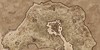
This is a common map produced by the Mappers Guild of the Imperial Capitol in Keizaal. It depicts the Imperial Captol Saarthal, its districts and the various gates. Due to the influx of temporary travelers each day arriving at the city to do business, these maps are produced en mass on cheap paper and distributed at various key areas of the city. These are mainly reserved for merchants and tradesmen arriving to do business, though travelling parties of nobility are given special exception.
The city itself was designed and constructed at the beginning of the second age by the Great Emperor Volk Sharp-Tooth. Though for the majority of his life he ruled from Solitude, he spent the last ten years of his reign in the Imperial Palace. Upon his death a statue a hundred feet high was commissioned and placed at the top of the grand stairway leading from the Imperial Council Building all the way down to Talos Bay.
Saarthal was chosen to be the Capitol after the Third Daedric Invasion destroyed the Imperial Island in Cyrodiil. The economic and political power base having moved centuries earlier, Emperor Volk decided that with the new age the first settlement of man would be rebuilt. It then, and now, is the largest, and most densly populated city in the entirety of the empire. It is one of the Three Sisters, coastal cities in Keizaal that are the nexus of trade.
Many consider Okaaz another part of the city because the two share a wall that has become less of a defensive structure, and more just a boarder division to keep the two cities from merging completely. Though due to their close proximity, politics, economy and culture often overlap.
The city itself was built on tiers in response to the terrain, and became the defining factor for the populace.
The Imperial district is the highest, and farthest away from the docks of Talos bay, containing much of the governing populace of the city and the empire.
The Talon District and the Noble District are the second tier, and thus home to the most influential citizenry of the city, as well as the city contingent of the Talons.
The Warehouse District, along with the Pocket District and the Hook District make up the final tier and surround Talos bay. It is the poorest part of the city and home to the peasantry.
Image size
1017x1170px 1.98 MB
© 2014 - 2024 SkullSmithy
Comments4
Join the community to add your comment. Already a deviant? Log In
It was supposed to read was a specific program used to make this