ShopDreamUp AI ArtDreamUp

Deviation Actions


![Tamriel Map [The Elder Scrolls Universe]](https://images-wixmp-ed30a86b8c4ca887773594c2.wixmp.com/f/5ea9225d-d795-4a75-a4c6-d0c98067b02f/d7c8zpx-578fef31-2335-40be-b78f-ba0d832967f3.jpg/v1/crop/w_184,h_184,x_21,y_0,scl_0.055255255255255,q_70,strp/tamriel_map___the_elder_scrolls_universe__by_martynasb_d7c8zpx-92s-2x.jpg?token=eyJ0eXAiOiJKV1QiLCJhbGciOiJIUzI1NiJ9.eyJzdWIiOiJ1cm46YXBwOjdlMGQxODg5ODIyNjQzNzNhNWYwZDQxNWVhMGQyNmUwIiwiaXNzIjoidXJuOmFwcDo3ZTBkMTg4OTgyMjY0MzczYTVmMGQ0MTVlYTBkMjZlMCIsIm9iaiI6W1t7ImhlaWdodCI6Ijw9MzMzMCIsInBhdGgiOiJcL2ZcLzVlYTkyMjVkLWQ3OTUtNGE3NS1hNGM2LWQwYzk4MDY3YjAyZlwvZDdjOHpweC01NzhmZWYzMS0yMzM1LTQwYmUtYjc4Zi1iYTBkODMyOTY3ZjMuanBnIiwid2lkdGgiOiI8PTQ4NjMifV1dLCJhdWQiOlsidXJuOnNlcnZpY2U6aW1hZ2Uub3BlcmF0aW9ucyJdfQ.iZ3rrFHu_TbI4jDCmJJVMRFmEMb0Zuh4HJz0yoHWPuc)
![Tamriel Map [The Elder Scrolls Universe]](https://images-wixmp-ed30a86b8c4ca887773594c2.wixmp.com/f/5ea9225d-d795-4a75-a4c6-d0c98067b02f/d7c8zpx-578fef31-2335-40be-b78f-ba0d832967f3.jpg/v1/crop/w_92,h_92,x_11,y_0,scl_0.027627627627628,q_70,strp/tamriel_map___the_elder_scrolls_universe__by_martynasb_d7c8zpx-92s.jpg?token=eyJ0eXAiOiJKV1QiLCJhbGciOiJIUzI1NiJ9.eyJzdWIiOiJ1cm46YXBwOjdlMGQxODg5ODIyNjQzNzNhNWYwZDQxNWVhMGQyNmUwIiwiaXNzIjoidXJuOmFwcDo3ZTBkMTg4OTgyMjY0MzczYTVmMGQ0MTVlYTBkMjZlMCIsIm9iaiI6W1t7ImhlaWdodCI6Ijw9MzMzMCIsInBhdGgiOiJcL2ZcLzVlYTkyMjVkLWQ3OTUtNGE3NS1hNGM2LWQwYzk4MDY3YjAyZlwvZDdjOHpweC01NzhmZWYzMS0yMzM1LTQwYmUtYjc4Zi1iYTBkODMyOTY3ZjMuanBnIiwid2lkdGgiOiI8PTQ4NjMifV1dLCJhdWQiOlsidXJuOnNlcnZpY2U6aW1hZ2Uub3BlcmF0aW9ucyJdfQ.iZ3rrFHu_TbI4jDCmJJVMRFmEMb0Zuh4HJz0yoHWPuc)


Badge Awards
Description
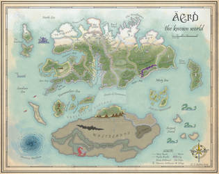
This is a map produced by the Imperial Library in Saarthal by the Imperial Cartographer Association. It describes in great detail all the roads, population centers, provinces, nations and empires of Tamriel in the 4th era, set before the beginning of the 'Great Endeavor'. It accompanies in the compendium "Histories of Tamriel" and is considered the most accurate maps of that time.
---
This map is based on the Beyond Skyrim Tamriel heightmap by Morcroft Darkes which is used with permission.
---
This map is based on the Beyond Skyrim Tamriel heightmap by Morcroft Darkes which is used with permission.
Image size
2190x1742px 7.48 MB
© 2015 - 2024 SkullSmithy
Comments56
Join the community to add your comment. Already a deviant? Log In
Isn't half of hammer fell still imperial controlled?